California's Earthquake History
Although earlier earthquakes have been documented—such as significant movement on the southern San Andreas fault all the way back to the 1600s—the earliest reported earthquake in California was on July 28, 1769, noted by members of a Spanish expedition to chart a land route from San Diego to Monterey. Members of the expedition led by Gaspar de Portolá were camped along the Santa Ana River when they felt a strong earthquake.
Based on descriptions of the quake, it was likely a moderate or strong earthquake. Some described the shaking in expedition diaries as violent, occurring over the next several days, suggesting aftershocks. Although the magnitude and epicenter are unclear, by comparing the descriptions with more recent events, the quake may have been similar in strength to the 1933 Long Beach or 1987 Whittier Narrows earthquake.
Jump to Earthquake Terminology and FAQs
Jump to the most Recent Earthquakes in California
Timeline of historical Earthquakes in California
Although most of California's quakes are small in magnitude and cause little or no damage, California experiences more than 100 per day!
Many notable shakers—moderate or major earthquakes in California—have made history and are still remembered and talked about today.
Take a look at noteworthy temblors in our state’s recorded history by viewing this California earthquake history timeline.
Ferndale 
December 20, 2022 | M6.4
In the early morning of December 20th, 2022, a magnitude 6.4 earthquake struck a few miles off the coast of Northern California, followed by at least a dozen smaller aftershocks. The quake was about 10 miles southwest of Ferndale, California, in Humboldt County.
Two people were killed and seventeen injured. The strong shaking damaged roads, homes, and utilities, according to the Humboldt County Office of Emergency Services. The quake was widely felt, with reports of weak shaking being felt hundreds of miles away.
This area, known as the Mendocino Triple Junction, has a long history of earthquakes. There have been over 40 earthquakes at or above magnitude 6.0 in the last hundred years within the region of this quake. "This area is the most seismically active part of California," said Keith Knudsen, Deputy Director of the USGS Earthquake Science Center.
Major quakes like this are a reminder that California is earthquake county, and it's important to be prepared. Learn how personal preparedness and practicing critical steps to safety can help you be ready. And if you own your home, one of the best things to do before the next big earthquake strikes is to strengthen it with a seismic retrofit. Get started at StrengthenMyHouse.com.

Antelope Valley
July 8, 2021 | M6.0
On the afternoon of July 8, 2021, at least several dozen earthquakes struck Little Antelope Valley, which is in Inyo National Forest, approximately 20 miles southwest of Smith Valley, Nevada. The quakes were a result of normal faulting and strike slip faults near the Antelope Valley fault, which runs north-south along the Sierra Nevada range front. The largest, a 6.0 magnitude, occurred along the eastern edge of the Sierra Nevada, a major physiographic boundary along the California-Nevada border.
The magnitude 6.0 earthquake was widely felt, with reports as far away as the San Francisco Bay Area and Sacramento in California, and Carson City in Nevada. Aftershocks continued to be felt into the night, with a magnitude 4.5 aftershock reported around 10:30 p.m. Damage from the earthquakes on July 8 was minor and included a rockslide in Coleville and items falling from shelves in nearby stores.
Even quakes that don’t cause major damage are a reminder that California is earthquake county, and it’s important to be prepared. Learn how personal preparedness and practicing critical steps to safety can help you be ready. And if you own your home, one of the best things to do before the next big earthquake strikes is to strengthen it with a seismic retrofit. Get started at StrengthenMyHouse.com.
Westmorland
September 30, 2020 | M4.9
A swarm of hundreds of small earthquakes south of the Salton Sea caused thousands of local people to feel “strong” shaking. The first quake on September 30, striking in the late afternoon, was a M3.0. The largest, a M4.9, struck at 5:31 p.m. The swarm lasted for several days, stabilizing at a low rate by Oct. 3. There were no reports of damage, but the swarm is a reminder to be earthquake ready.
According to USGS, this earthquake swarm is in an area of diffuse seismic activity between the San Andreas fault to the north and the Imperial fault to the south. Past swarms in this area include the 1981 Westmorland swarm, where the highest magnitude was a 5.8, and the 2012 Brawley Storm, which included a M5.4 quake. In August of 2020, a swarm of earthquakes had also struck in the same area, the largest being a magnitude 4.6 at Bombay Beach.
South El Monte
September 18, 2020 | M4.5
A magnitude 4.5 earthquake struck in Los Angeles, about 10 miles east of the Los Angeles Civic Center, late at night on September 18. It was widely felt across the region, even as far south as San Diego, and was followed by several aftershocks.
The area is seismically active—this quake was not far from the epicenter of the 1987 Whittier Narrows earthquake, which caused extensive damage. In 2014, the La Habra quake struck along the Puente Hills thrust fault, displacing residents. The thrust fault is considered especially dangerous as it runs along a dense urban area (downtown Los Angeles).
Luckily, there were no reports of serious injuries or damage from this quake, but it’s a reminder that when there is shaking, you should practice personal preparedness and Drop, Cover, and Hold On until the shaking stops.
Lone Pine
June 24, 2020 | M5.8
After a foreshock with a magnitude of 4.6 two days earlier, on June 24, a magnitude 5.8 earthquake struck about 12 miles southeast of Lone Pine, in Inyo County. People felt the shaking as far away as 350 miles northwest in San Francisco and 230 miles east in Las Vegas. People reported feeling shaking as far as Sacramento and Los Angeles, too. Campers at Mount Whitney were evacuated after a rockslide—which was triggered by the shaking—caused “truck-sized boulders” to fly off the mountain, with one landing on the trailhead. CEA had approximately 150 policyholders in the affected area.
According to the Los Angeles Times, a quake of this magnitude “may cause slight and moderate damage in well-built ordinary structures and considerable damage in poorly built or badly designed structures and may break chimneys.” If you own an older home, it is recommended to retrofit it to make it more resistant against shaking. Learn more at StrengthenMyHouse.com.
Searles Valley
June 3, 2020 | M5.5
On June 3, 2020, a magnitude 5.5 earthquake struck about 13 miles from Ridgecrest, and 10 miles south of Searles Valley, in the Mojave Desert.
Dr. Lucy Jones tweeted that it was a large, late aftershock of the 2019 Ridgecrest sequence, which produced quakes as large as M6.4 and M7.1. Residents in the area expressed anxiety about this new shaker, noting they never know if it is an aftershock or a sign of a larger quake to come. Learn how to be better prepared to survive and recover from an earthquake by reading about what to do before an earthquake strikes.
Ridgecrest
July 5, 2019 | M7.1
A magnitude 7.1 earthquake struck 10.5 miles north-northwest of Ridgecrest in the Mojave Desert on Friday, July 5, 2019, at 8:19 p.m., on the heels of a magnitude 6.4 earthquake that struck about 7.5 miles southwest of the Searles Valley in the Mojave Desert on Thursday, July 4, 2019, at 10:33 a.m.
Multiple aftershocks occurred after both, one as large as magnitude 5.5. The 7.1 earthquake was stronger than any earthquakes in the region in about 20 years.
- Read more about the 2019 Ridgecrest earthquake sequence in our blog post: The Recent Earthquakes near Ridgecrest, California
Borrego Springs
June 10, 2016 | M5.2
On June 10, 2016, people near Borrego Springs were woken up at 1:04 a.m. by a magnitude 5.2 earthquake. The quake occurred on the San Jacinto fault, which is considered by experts to be the most active fault in Southern California.
Luckily, the quake caused no major damage—just some fallen household items and store merchandise—but was felt throughout a large portion of Southern California.
There were hundreds of reported aftershocks.
American Canyon (South Napa)
August 24, 2014 | M6.0
In the early morning of August 24, 2014, a magnitude 6.0 earthquake a few miles northwest of American Canyon caused injuries and damage in Napa County and Solano County. In Napa County, the quake killed one person, injured at least 208 people, and caused severe damage to 150 buildings and moderate damage to more than 1,000 buildings. In Solano County, it injured at least 49 people, caused severe damage to 10 buildings and caused moderate damage to more than 30 buildings
The quake also damaged roads, water mains and gas lines in these counties; disrupted utility services in Sonoma County; and caused fires in Napa County. The total economic loss was estimated at $400 million. This earthquake was felt as far north as Arcata and as far south as Bakersfield. It was also felt in numerous cities in Nevada.
- Read more from our Press Release: A Year After South Napa Earthquake, Damage Proves Widespread and Costly
La Habra
March 28, 2014 | M5.1
The magnitude 5.1 La Habra earthquake occurred on March 28, 2014. It was felt throughout Southern California, including in Orange, Los Angeles, Ventura, Riverside and San Bernardino counties.
The quake resulted in power outages and damage including ruptured water mains, broken glass and rockslides (one even caused a car to overturn). It happened just an hour after a magnitude 3.6 foreshock in the same area. Nearly two dozen aftershocks followed.
- Read our press release on the Five-Year Anniversary of the La Habra Earthquake
Westwood
March 17, 2014 | M4.4
On March 17, 2014, a magnitude 4.4 earthquake occurred about two miles south-southeast of Encino. The earthquake was felt in Los Angeles, Ventura, San Bernardino and Orange counties.
This was the largest earthquake in Los Angeles since the aftershocks of the 1994 Northridge quake. At least six aftershocks were reported.
Ferndale
March 9, 2014 | M6.8
On the night of March 9, 2014, a magnitude 6.8 earthquake struck 50 miles off the coast of Northern California near Ferndale. While there was no recorded damage, the quake was felt widely.
Canyondam
May 23, 2013 | M5.7
On May 23, a magnitude 5.7 (Mw) earthquake occurred near the town of Greenville, at the corner of Lake Almanor. It damaged chimneys, caused broken water pipes and rock falls, and caused one house to shift off of its foundation.
The quake was felt widely in Northern California and in parts of Oregon and Nevada.
Brawley
August 26, 2012 | M5.4
On August 26, 2012, a magnitude 5.4 earthquake occurred about four miles north of the town of Brawley. It was part of a swarm of at least 600 events of varying magnitudes, ranging from smaller than 2.0 to 5.4.
El Mayor-Cucapah (Baja CA/Mexico)
April 4, 2010 | M7.2
On April 4, 2010, the magnitude 7.2 El Mayor-Cucapah earthquake occurred in Mexico. It was centered in Baja California and felt throughout that region, Southern California, Arizona and Nevada. It was the largest earthquake to strike in this area since 1892. Liquefaction was widespread, causing damage to farmland, highways, buildings and homes.
- Watch a video from CEA CEO Glenn Pomeroy as he looks back on this earthquake.
Eureka
January 9, 2010 | M6.5
On January 10, 2010, a magnitude 6.5 earthquake occurred off the coast of Northern California near Eureka and Ferndale. Broken glass injured some people at a local mall, and mild to moderate damage to homes and buildings occurred. This earthquake was felt throughout Northern California and parts of Oregon and Nevada.
Chino Hills
July 29, 2008 | M5.4
A little before noon, on July 29, 2008, a magnitude 5.4 earthquake occurred about five miles northeast of Yorba Linda, shaking buildings in downtown Los Angeles. It was felt as far away as Las Vegas.
While the quake caused no deaths, the shaking was strong enough that Disneyland, Knott’s Berry Farm and other amusement parks in the area reportedly evacuated and temporarily closed rides. Notable damage to some structures in the area included buildings at California State University, Fullerton; Placentia’s public library; the Nixon Presidential Library and Museum in Yorba Linda; and Chapman University. There also were minor injuries, power outages and transit disruptions, and a fire began in a movie theater in Santa Ana as a result of a damaged light fixture.
Alum Rock
October 30, 2007 | M5.6
On October 30, 2007, an earthquake with a preliminary magnitude 5.6 occurred on the Calaveras fault near Alum Rock. Later downgraded to a magnitude 5.4 (Mw), the earthquake was felt by most people in the San Francisco Bay Area but luckily only caused minor damage in the San Jose area. This is because the epicenter was to the southeast of populated centers, and the fault ruptured southward, away from those populated areas.
Parkfield
September 28, 2004 | M6.0
On September 28, 2004, a magnitude 6.0 earthquake occurred on the San Andreas fault near Parkfield. It ruptured the same segment that ruptured in 1966 and was the seventh earthquake on this stretch of the fault since 1857. Strong shaking was felt for about 10 seconds.
San Simeon
December 22, 2003 | M6.5
The December 22, 2003, San Simeon earthquake, which had a magnitude 6.5 and numerous aftershocks, led to a change in California law. The most severe damage from this quake was to unreinforced masonry structures that had not been seismically retrofitted in order to better withstand earthquakes.
In Paso Robles, the collapse of one of these such building types collapsed, killing two women. Because of this, California enacted a law that requires certain unreinforced masonry buildings that haven’t been retrofitted to post a warning about potential hazards during an earthquake.
West Hollywood
September 9, 2001 | M4.2
On September 9, 2001, a magnitude 4.2 earthquake occurred about a mile east-southeast of West Hollywood. The light quake was felt throughout the Los Angeles area and in parts of the San Fernando Valley. It caused some dishes to fall, but there were no major injuries or damage. A magnitude 2.8 aftershock occurred immediately after the initial main shock.
Portola
August 10, 2001 | M5.5
On August 10, 2001, a magnitude 5.5 earthquake occurred in a remote area of Northern California. It caused slight damage in the towns of Portola and Quincy in Plumas County. The earthquake was felt widely, in Sacramento to the south and in Reno, Nevada, to the east. A spokesperson for the U.S. Geological Survey said the widely felt shaking wasn’t surprising, because the granite in that area is a great conductor for spreading shock waves great distances.
Yountville
September 3, 2000 | M5.0
A magnitude 5.0 earthquake struck in the Yountville (Napa) area in the middle of the night on September 3, 2000. It was felt in many parts of Northern California, including the Bay Area, the Sacramento area and Santa Rosa. It caused one death and more than 40 injuries, including the critical injury of a young boy who was hurt by falling fireplace bricks.
The quake occurred on a previously unknown fault. Damage was estimated at $65 million, with 2,000 houses needing chimney repair.
Hector Mine
October 16, 1999 | M7.1
On October 16, 1999, the magnitude 7.1 (Mw) Hector Mine earthquake occurred in the Mojave Desert. A small cluster of foreshocks began almost a day before the mainshock. Luckily, despite its size, the quake didn’t cause much damage because of its remote location.
The Hector Mine quake reportedly knocked a passenger train off a track, however, causing a few people to sustain minor injuries, and it damaged two highway bridges. It also caused short power outages to more than 250,000 customers in Southern California.
Redding
November 26, 1998 | M5.2
A magnitude 5.2 earthquake occurred in Redding on Thanksgiving Day in 1998, causing minor damage such as broken windows and fallen household and retail items. Additionally, there were a couple of small aftershocks.
San Juan Bautista
August 12, 1998 | M5.4
On August 12, 1998, a magnitude 5.4 earthquake occurred on the San Andreas fault eight miles southwest of Hollister and was felt as far north as San Francisco. The earthquake injured two people in Santa Cruz County and caused damage such as cracks in plaster walls, cracks on Highway 101, and fallen household items. Additionally, utility services were briefly disrupted in some locations.
Coso
November 27, 1996 | M5.3
On November 27, 1996, a magnitude 5.3 earthquake occurred about 17 miles northeast of Little Lake and was widely felt in the Ridgecrest area and southern Owens Valley. This earthquake’s location and size prevented it from producing a lot of damage, but it did produce a high number of aftershocks—more than 3,000 in the six months after the main earthquake!
Ridgecrest
September 20, 1995 | M5.8
Two earthquakes occurred in 1995 in the same general area, about 10 miles north of the town of Ridgecrest, just about a month apart. The first, on August 17, was a magnitude 5.4 quake. It produced more than 2,500 aftershocks in the five weeks that followed. The second significant shock was on September 20, with a magnitude of 5.8. The second quake produced close to 2,000 aftershocks! The first quake in August has been described as a “major foreshock” to the September 20 "mainshock.”
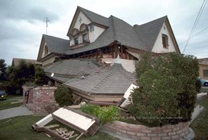
Northridge
January 17, 1994 | M6.7
On January 17, 1994, a magnitude 6.7 earthquake struck near Northridge. The quake destroyed or severely damaged thousands of single-family homes, apartments and mobilehomes, displacing about 22,000 people from their homes and causing residential damage estimated at more than $20 billion—the equivalent of nearly $35 billion today—about half of which was insured.
The quake hit the insurance industry hard: many insurers had greatly underestimated the costs associated with a major earthquake. By 1995, many had restricted or stopped writing residential insurance policies, sending the California housing market into a tailspin. In response to this crisis, CEA was created.
- Learn more from our Community Story: On its 25th Anniversary, CEA Remembers the Northridge Earthquake
Landers & Big Bear
June 28, 1992 | M6.5
On the early morning of June 28, 1992, a magnitude 7.3 (Mw) earthquake—the largest Southern California earthquake in 40 years—struck, rupturing five different faults! Although its epicenter was in a sparsely populated area, it was said to have been felt throughout the Los Angeles area, Arizona, Nevada, and Idaho.
That same morning, a magnitude 6.5 (Mw) earthquake occurred in Big Bear and was considered to be the largest major aftershock of the Landers quake. This quake caused considerable damage in the Big Bear area, causing a 44-mile-long fault rupture and landslides that blocked and damaged roads in the San Bernardino Mountains.
Between the two quakes, at least 400 people were injured, one child died from a fallen chimney, and two others died of heart attacks.
Cape Mendocino
April 25, 1992 | M7.2
The 1992 Cape Mendocino earthquakes struck near Petrolia on April 25, 1992. The first quake, a magnitude 7.2, was followed the next day by two aftershocks of approximately magnitudes 6.5 and 6.7. The shaking caused severe damage, massive landslides, a tsunami, and injured hundreds of people. The quake also shook the Petrolia fire house so hard that the garage door jammed, trapping the fire engine inside. The volunteer fire crew was then unable to put out the fires that followed the quake.
Joshua Tree
April 22, 1992 | M6.1
On April 22, 1992, a magnitude 6.1 (Mw) earthquake occurred about 11 miles east of Desert Hot Springs, following a 4.6 foreshock. It caused slight to moderate damage in Joshua Tree, Yucca Valley, Desert Hot Springs, Palm Springs and Twentynine Palms. More than 30 people were treated for minor injuries. There were several aftershocks. The quake was felt as far away as San Diego and Santa Barbara, Las Vegas, Nevada, and even Phoenix, Arizona.
Sierra Madre
June 28, 1991 | M5.8
On the morning of June 28, 1991, a magnitude 5.8 (ML) earthquake occurred about 12 miles northeast of Pasadena. It caused two deaths, at least 100 injuries and about $40 million in property damage in the San Gabriel Valley. Unreinforced masonry buildings suffered the most damage. The quake also caused rockslides that blocked mountain roads.
Loma Prieta (World Series)
October 17, 1989 | M6.9
The magnitude 6.9 Loma Prieta earthquake on October 17, 1989, known as the “World Series earthquake,” caused 63 deaths, 3,757 injuries and more than $5.9 billion in property damage. It was felt extensively throughout the entire Bay Area. The Loma Prieta quake was the first major event to occur along the San Andreas fault zone since the 1906 San Francisco earthquake.
- Learn more from our Community Story: CEA Staff Remember the Loma Prieta Earthquake
A house damaged by the Loma Prieta earthquake. Photo credit: U.S. Geological Survey.
Whittier Narrows
October 1, 1987 | M5.9
On October 1, 1987, a magnitude 5.9 (ML) earthquake on a previously unknown fault occurred about seven miles southeast of Pasadena. It caused eight deaths.
The quake also caused $358 million in property damage, with the most severe damage near the epicenter and in the Uptown district of Whittier, the downtown section of Alhambra and the Old Town section of Pasadena, all of which had unreinforced masonry buildings. More vulnerable types of residences, such as those not anchored to their foundations, those constructed of masonry, or houses built over garages with large door openings, sustained the most damage.
- Read what CEA had to say on the 30th anniversary of the Whittier Narrows earthquake.
Chalfant Valley
July 21, 1986 | M6.5
On July 21, 1986, a magnitude 6.5 (ML) earthquake struck near the towns of Bishop and Chalfant, injuring two people. The quake fractured ground in some places, caused rockslides and landslides in others, and caused significant property damage.
Damage included broken ceiling tiles, plaster, chimneys, windows and walls at buildings in Bishop, as well as damage to homes and utility lines in Chalfant when mobilehomes were shaken off their supports. The earthquake was felt as far away as Salt Lake City, Utah. Foreshocks had been felt for up to three weeks prior.
Oceanside
July 13, 1986 | M5.4
On the morning of July 13, 1986, a magnitude 5.4 (ML) earthquake occurred offshore about 35 miles northwest of San Diego. Twenty-nine people were hurt, and one person died. The damage, to at least 50 buildings, stretched from Newport Beach to San Diego, and there was also a small landslide in eastern San Diego County. The quake caused $1 million in damage. There was a large aftershock sequence, also offshore.
North Palm Springs
July 8, 1986 | M5.6
On July 8, 1986, a magnitude 5.6 (ML) earthquake occurred about six miles northwest of North Palm Springs, on either the Banning fault or the Garnet Hill fault. It caused at least 29 injuries, damaged or destroyed more than 50 homes in the Palm Springs-Morongo Valley area and caused landslides. The quake resulted in an estimated $4 million in total damage.
Morgan Hill
April 24, 1984 | M6.2
This magnitude 6.2 (ML) earthquake on April 24, 1984, presumably on the Calaveras fault, was felt throughout Central California. Its epicenter was located near Halls Valley, east of San Jose, in Santa Clara County. Damage was concentrated closer to the town of Morgan Hill and the Anderson Reservoir.
The California Office of Emergency Services estimated $7 million in damage to private property and an additional $500,000 in damage to local-government-owned facilities.
Coalinga
May 2, 1983 | M6.7
Longtime residents of the Central Valley will remember the Coalinga earthquake of May 2, 1983, which occurred on a previously unknown fault and injured 94 people, mostly from furniture and other items falling or being thrown about, and from people being knocked to the ground from the shaking.
The magnitude 6.7 (ML) earthquake almost completely destroyed the eight-block downtown commercial district of Coalinga.
An assessment by the American Red Cross stated that 309 single-family houses and 33 apartment buildings were almost destroyed; 558 single-family houses, 94 mobilehomes and 39 apartment buildings sustained major damage; and 811 single-family houses, 22 mobilehomes and 70 apartment buildings sustained minor damage.
- Read what CEA had to say on the 35th anniversary of the Coalinga earthquake.
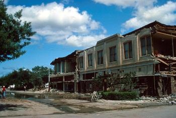
Failed cornice and exterior walls of a building in the restricted area of heavily damaged downtown Coalinga. May 4, 1983.
Photo credit: U.S. Geological Survey.
Humboldt
November 8, 1980 | M7.0
On November 8, 1980, a magnitude 7.0 (ML) earthquake, known as the Gorda Basin or Humboldt earthquake, occurred off the coast of Humboldt County. Six people were injured, and aftershocks were felt for days. The earthquake was felt in parts of California, Oregon and Nevada.
Considering the size of the quake, damage was light, although structural damage did occur. Chimneys fell and, in Fields Landing, at least four wood-frame houses were shifted off their foundations, with two falling partly to the ground. Also, Tompkins Hill Road overpass suffered partial collapse, and there were a few minor landslides, areas of liquefaction, and ground cracks.
Mammoth Lakes
May 25, 1980 | M6.0
On May 25, 1980, around 9:30 a.m., an earthquake of magnitude 6.0 occurred east-southeast of Mammoth Lakes. In the next 16 minutes, five shocks between magnitude 4.1 and 5.5 occurred.
Within 48 hours of the initial quake, 72 magnitude 4.0 – 4.9 events, six magnitude 5.0 – 5.5 events and three events of magnitude 6.0 – 6.3 struck. There were also thousands of shakes under magnitude 3.9.
Damage in the Mammoth Lakes area was estimated at around $2 million and included damage to roads, buildings (including schools), water mains, merchandise and personal property. There were also widespread landslides and rockfalls.
White Wash
February 25, 1980 | M5.5
In the middle of the night on February 25, 1980, a magnitude 5.5 (ML) earthquake struck about 25 miles south of Palm Springs. It was not considered a major earthquake or even a highly damaging earthquake—no injuries were reported—but it did cause landslides that closed Highway 74 between Spring Crest and Palm Springs, and it also caused a fire in Rancho Mirage when a gas line broke in a home. Additionally, minor damage, such as broken dishes and windows, was reported in many parts of Southern California.
Imperial Valley
October 15, 1979 | M6.4
On October 15, 1979, a magnitude 6.4 (Mw) earthquake occurred about 18 miles southeast of El Centro, injuring 91 people.
The quake destroyed two houses and 11 commercial buildings and damaged more than 1,500 houses and more than 400 commercial buildings. The Imperial County Services building in El Centro had to be razed after the eastern part of the building partly collapsed. The quake also caused property damage in El Centro, Brawley and Calexico and in Mexicali, Mexico, and it damaged irrigation systems in the Imperial Valley, such as the All American Canal.
Coyote Lake
August 6, 1979 | M5.7
A magnitude 5.7 earthquake on August 6, 1979, injured 16 people in the towns of Hollister and Gilroy and caused an estimated $500,000 in property damage in these towns. This included damage to chimneys in older houses, broken glassware in stores, and structural damage to five buildings in the town of Gilroy. For example, in Gilroy, a wall cracked in the City Hall building, and a ceiling caved in inside a room within the Municipal Courthouse. In Hollister, a real estate office’s roof caved in, and a department store sustained damage to beams.
The earthquake damaged a fire station at Pacheco Pass, and a nearby lookout station was vacated because of damage, as well. This earthquake was felt near Bakersfield and Sacramento, and at least 312 aftershocks were recorded.
Santa Barbara
August 13, 1978 | M5.1
In the late afternoon of August 13, 1978, a magnitude 5.1 (ML) earthquake occurred about a mile southeast of Santa Barbara. This earthquake caused significant damage for its size: at least 65 people injured and about $15 million in property damage. Notable damage included a freight train being derailed, a roof collapsing, and several buildings and at least one bridge being damaged.
By amazing coincidence, just one day before the earthquake and its aftershocks happened, four new seismographs were installed in the area near the epicenter!
Oroville
August 1, 1975 | M5.7
The magnitude 5.7 earthquake that occurred near Oroville-Thermalito on the night of August 1, 1975, was associated with the first recorded surface faulting in the western foothills of the Sierra Nevada.
It was felt in many parts of Northern California and Western Nevada. This earthquake also caused structural damage (cracked chimneys, walls, windows and plaster) at several schools, homes and hospitals in southern Butte County. Property damage was estimated at $2.5 million.
San Fernando
February 9, 1971 | M6.5
On February 9, 1971, a magnitude 6.5 (Mw) earthquake, also called the Sylmar earthquake, struck in the northwestern part of Los Angeles County in the San Gabriel Mountains, just after 6 a.m.
Although the area was sparsely populated, there were 65 deaths, most of which were caused by the collapse of the Veteran’s Administration Hospital. More than 2,000 people were injured. Several other hospitals were also damaged, and newly constructed freeway overpasses collapsed. Had the quake struck at a busier time of day, loss of life would have likely been even greater.

A collapsed overpass at the interchange of Interstates 5 (the Golden State Freeway) and 210 (the Foothill Freeway). Seismic shaking, compression and extension along the length of the roadway were responsible for the damage in this image. This view, looking east, shows the overpass, which was completed (although not all segments were yet in service), as well as San Fernando Valley Juvenile Hall at right. Feb 11, 1971.
Photo credit: U.S. Geological Survey.
Borrego Mountain
April 8, 1968 | M6.5
On April 8, 1968, a magnitude 6.5 (Mw) earthquake occurred about a mile north of Ocotillo Wells, about 40 miles south of Indio. It was felt as far away as the Yosemite Valley, Fresno and Las Vegas, and it caused damage across much of Southern California: power lines severed in San Diego County, collapsed ceilings in the Imperial Valley, cracked plaster in Los Angeles, landslides close to the epicenter, and minor surface rupture that cracked Highway 78.
The earthquake also caused small displacements along the Superstition Hills fault, Imperial fault and Banning-Mission Creek fault, miles from the epicenter.
Truckee
September 12, 1966 | M5.9
On September 12, 1966, a magnitude 5.9 earthquake occurred northeast of the town of Truckee. Damage such as fallen chimneys and cracked walls occurred in nearby Loyalton, Sierraville, Boca, Hirschdale and Hobart Mills. There were landslides and rockslides, and pipelines, bridges, dams and roads were also affected.
The quake was felt over a large area of east-central California and in northwest Nevada.
Parkfield
June 27, 1966 | M6.0
On June 27, 1966, a magnitude 6.0 (ML) earthquake occurred about six miles northwest of the town of Parkfield. Luckily, little damage was reported, because the area was not well-populated.
There had been five magnitude 6 earthquakes in the same area prior to the 1966 earthquake, occurring in 1857, 1881, 1901, 1922 and 1934.
Daly City
March 23, 1957 | M4.2
Two earthquakes in March 1957, a magnitude 5.3 on March 22 and a magnitude 4.2 on March 23, injured 40 people and caused an estimated $1 million in property damage. One death is attributed to the March 22 earthquake.
In Daly City, chimneys were damaged, and there was some minor damage at homes near the ocean west of Daly City. In San Francisco, the earthquakes damaged chimneys, plaster, windows and merchandise. There were also cracks on the shoulder of Highway 1, as well as landslides blocking the roadway near Mussel Rock.
Eureka
December 21, 1954 | M6.5
On December 21, 1954, a magnitude 6.5 earthquake occurred near Eureka. The quake caused significant property damage (estimated at more than $2 million), as well as one death and around 50 injuries.
Damage included cracks to government buildings, such as the county courthouse and Eureka’s City Hall, as well as damage to concrete and wood-framed buildings in the area, such as cracked chimneys, plaster and windows. Some underground utilities were also damaged, and a water tank collapsed.
San Jacinto Fault (Arroyo Salada)
March 19, 1954 | M6.4
On March 19, 1954, a magnitude 6.4 (Mw) earthquake occurred about 30 miles south of Indio. It caused damage in many cities in Southern California, such as cracked walls in San Diego, damaged ceiling plaster in Los Angeles’ City Hall, cracked swimming pool walls in Palm Springs, a broken water pipe in Palm Springs, snapped power lines in San Bernardino and other minor damage in Indio and Coachella.
The quake was felt as far away as Las Vegas in the east and Ventura County in the west.
Kern County
July 21, 1952 | M7.5
The magnitude 7.5 (Mw) earthquake that occurred on July 21, 1952, was the largest earthquake in Southern California in more than 80 years. It was felt over a large area, including in Nevada, San Francisco and San Diego—and even caused damage in these locations.
It caused 12 deaths, 18 injuries and at least $50 million in property damage. At least 20 of this quake’s aftershocks were of magnitude 5.0 or greater. Hundreds of buildings in the Kern County area were damaged, and at least 100 buildings had to be torn down as a result of this earthquake. There was extensive damage to a railroad section, and to land used for agriculture and irrigation.
The quake occurred on the White Wolf fault, which was not previously considered a major threat.
- Read what CEA had to say on the 65th anniversary of the Kern County earthquake.

The 1952 Kern County earthquake damaged a section of Southern Pacific Railroad line near the town of Bealville. Note the sharp bend in the track and the landslide covering the track closer to the tunnel’s entrance.
Photo credit: U.S. Geological Survey.
Desert Hot Springs
December 4, 1948 | M6.0
On December 4, 1948, a magnitude 6.0 (Mw) earthquake occurred about five miles east of Desert Hot Springs, north of Palm Springs. Fortunately, no lives were lost. It was felt as far north as Bakersfield, as far west as Catalina Island, as far east as Central Arizona and as far south as Mexico.
In Los Angeles, about 100 miles away from Desert Hot Springs, a 5,800-gallon water tank split open. Water pipes broke in Pasadena and at the University of California, Los Angeles, and a water main broke in San Diego. Walls and buildings cracked in Escondido, Corona and Pasadena.
Landslides and ground cracks occurred closer to the epicenter. In Palm Springs, two people were injured, buildings were damaged or collapsed, and thousands of dollars of merchandise was destroyed when it fell from shelves.
Manix
April 10, 1947 | M6.5
On April 10, 1947, a magnitude 6.5 (Mw) earthquake occurred about 25 miles east of Barstow. Because of its remote location, it didn’t cause a lot of damage. However, there were reports of cracked floors and walls, a few collapsed structures, and heavy objects being moved.
This quake was notable because it was the largest earthquake at that time—and the first to cause surface rupture (about three miles of rupture)—in the Mojave Block tectonic region.
Fish Creek Mountains
October 21, 1942 | M6.6
On October 21, 1942, an earthquake of magnitude 6.6 (Mw) occurred south of the Salton Sea, about 27 miles west of the town of Brawley and about 60 miles east of San Diego on the southern section of the Coyote Creek fault, in the southernmost section of the San Jacinto fault zone. San Diegans felt at least 40 aftershocks in the week following the initial earthquake.
Because its location was in a relatively unpopulated area, the earthquake caused relatively little damage: rockslides in Carrizo Gorge, which blocked a highway and railroad track; moderate damage in Jacumba Hot Springs, near the Mexico border; and minor damage in Brawley, El Centro, Westmoreland and San Diego.
Santa Barbara
June 30, 1941 | M5.5
On June 30, 1941, a magnitude 5.5 (ML) earthquake occurred about six miles east-southeast of Santa Barbara. It was felt as far away as Mojave, Lake Arrowhead and San Diego and caused an estimated $150,000 in damage, including cracks in water mains, walls and even streetlights.
Imperial Valley
May 18, 1940 | M6.9
On May 18, 1940, a magnitude 6.9 (Mw) earthquake struck about five miles north of Calexico, along the Mexico border. It was the strongest earthquake ever recorded to strike in the Imperial Valley and was felt far away, in Los Angeles and even Tucson, Arizona.
It caused at least eight deaths, seriously injured at least 20 people and caused at least $6 million in direct damage (not including lost crops because of irrigation system damage). It caused a water tank to collapse in Imperial, damaged railroad bridges in California and Mexico, displaced roadway and railroad segments in many areas, swayed tall buildings in Los Angeles, collapsed buildings closer to the quake in Brawley and El Centro, and caused extensive damage to irrigation systems.
The Imperial fault had surface rupture of at least 25 miles, most likely much longer.
Long Beach
March 10, 1933 | M6.4
Around dinnertime on March 10, 1933, a magnitude 6.4 (Mw) earthquake occurred on the Newport-Inglewood fault zone, causing 120 deaths. It is estimated that about two-thirds of these deaths occurred because people ran out of buildings and were hit by falling debris. There were also more than 500 injuries reported in Long Beach alone, and the quake caused more than $50 million in property damage, mostly to poorly built structures and unreinforced buildings.
Fatalities would have been even higher if the quake had struck during school hours: 70 schools were destroyed, and 120 were damaged. This earthquake led to the California Legislature enacting the Field Act, which gave the State Division of Architecture authority and responsibility for approving design and supervising construction of public schools. Building codes were also improved.
Since the passage of the Field Act, no school in California has collapsed as a result of a seismic event.
- Read what CEA had to say on the 85th anniversary of the Long Beach earthquake.

East Compton Junior High School, in Compton damaged by the 1933 Long Beach earthquake.
Photo credit: U.S. Geological Survey.
Eureka
June 6, 1932 | M6.4
On June 6, 1932, the magnitude 6.4 (ML) Eureka earthquake (magnitude 5.9 Mw) occurred near Eureka. A falling chimney killed one person, and the quake caused several injuries and caused significant property damage in Eureka, Arcata, Fields Landing and other nearby towns.
Damage included the shaking down of small houses, fallen and cracked chimneys, broken windows, broken water mains, cracked highways and damaged walls. This earthquake was strong enough to be felt hundreds of miles away, in San Jose, as well as in Oregon and Nevada.
Lompoc
November 4, 1927 | M7.1
On November 4, 1927, a magnitude 7.1 (ML) earthquake struck about 10 miles offshore from Lompoc. The earthquake also produced a sea-quake, which killed and stunned fish near Point Arguello and shook at least two ships in the area.
On land, the quake caused people to fall to the ground and caused damage—such as broken chimneys, houses shifting on their foundations, collapse of buildings, cracked walls and damage to a railroad bridge—in the coastal town closest to the epicenter.
This earthquake also caused a tsunami up and down the coast, recorded in San Francisco, La Jolla, San Diego and Fort Point.
Santa Barbara
June 29, 1925 | M6.8
On June 29, 1925, a magnitude 6.8 earthquake occurred near Santa Barbara. Shaking was felt in Paso Robles in San Luis Obispo County in the north, in Santa Ana in Orange County in the south, and to Mojave in Kern County in the east.
The quake killed 13 people and caused property damage estimated at $8 million in Santa Barbara, other coastal towns, and towns within the Santa Ynez Mountains and Santa Maria River valleys. Because portions of Santa Barbara were built on landfill, many structures were demolished. Additionally, this earthquake caused landslides in bluffs adjacent to the ocean, as well as damage to railroad tracks in the area.
Strong aftershocks were felt throughout the month of July 1925.
North San Jacinto Fault
July 22, 1923 | M6.3
Striking a little before midnight on July 22, 1923, a magnitude 6.3 (ML) earthquake occurred about seven miles south of San Bernardino. Two people were critically injured, but luckily no deaths were reported.
Minor damage—chimneys falling and windows breaking—occurred in Redlands and San Bernardino. San Bernardino’s county hospital and hall of records were badly damaged, as was the state hospital at Patton. Additionally, trees fell in the San Bernardino Mountains nearby.
Humboldt
January 22, 1923 | M7.1
On January 22, 1923, a magnitude 7.1 earthquake struck off the coast of Humboldt County. It caused damage to houses in Ferndale, Petrolia, Upper Mattole, Pepperwood, Alton, Fortuna and other local towns. Damage included broken chimneys, separation of houses from their foundations, and broken utility lines. It also caused a small tsunami and aftershocks.
San Jacinto
April 21, 1918 | M6.8
On April 21, 1918, a magnitude 6.8 (ML) earthquake occurred near the town of San Jacinto. It was a Sunday, which meant business districts in San Jacinto and nearby Hemet were empty, so the number of fatalities and injuries was lower than it might have been on a weekday, with only a few injuries and one reported death.
This earthquake was felt in Arizona and Baja California, as well. The amount of damage in the business districts was significant, and many large masonry structures collapsed. The quake also caused landslides, which resulted in at least one car accident, and blocked roads, including the road from Hemet to Idyllwild. Near Winchester, two miners were trapped in a mine temporarily. Additionally, the shaking caused cracks in the ground, roads and irrigation canals.
Imperial Valley
June 22, 1915 | M6.3
On June 22, 1915, two separate earthquakes occurred about an hour apart near El Centro. The first, a magnitude 6.1 (ML) earthquake, occurred around 7 p.m. and weakened many structures in the region. The second, a magnitude 6.3 (ML) earthquake occurred around 9 p.m. and caused many of the structures weakened in the first quake to collapse.
The first shock had caused many people to exit buildings and move into the streets, and because many of them had not yet returned to the buildings when the second quake occurred, severe injuries were limited.
However, in Mexicali, Mexico, less than 20 miles south of El Centro, dance halls and gambling halls had been busy before the first quake and continued to operate afterward, so many people returned to them. As a result, six deaths and many injuries occurred in Mexicali when weakened structures collapsed with patrons inside them or when materials inside the structures fell.
Elsinore
May 15, 1910 | M6.0
On May 15, 1910, a magnitude 6.0 (ML) earthquake occurred northwest of Lake Elsinore, about 15 miles south of Riverside. It had been preceded by moderate foreshocks on April 10 and May 12. It was not considered to be strong or damaging, apart from toppling some chimneys in Corona, Temescal and Wildomar.
The quake it is notable because its epicenter was thought to be somewhere along the Elsinore fault zone, in Temescal Valley, and no other earthquakes this large have been recorded along this fault zone.
San Francisco
April 18, 1906 | M7.9
The magnitude 7.9 (Mw) San Francisco earthquake that occurred on April 18, 1906, is one of California’s most famous earthquakes.
It was the result of a rupture on the San Andreas fault that caused strong shaking felt as far north as Eureka and as far south as Salinas. It caused more than 3,000 deaths, approximately 225,000 injuries and $400 million in property damage.
Damage occurred well beyond San Francisco, such as into nearby Santa Cruz, San Benito and Monterey counties, where buildings collapsed, bridges were damaged, and river courses were altered.
- Read our press release from the 110-year anniversary of this quake.
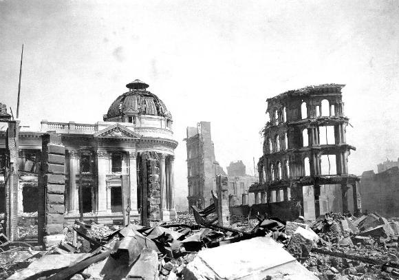
The earthquake- and fire-wrecked Hibernia Bank Building in San Francisco, following the 1906 earthquake.
Photo credit: U.S. Geological Survey.
San Jacinto Fault Zone
December 25, 1899 | M6.5
It caused six deaths on the Soboba Indian Reservation, as adobe walls fell on people there. It also badly damaged or destroyed almost all the brick buildings in San Jacinto and nearby Hemet. In Riverside, the quake resulted in cracked walls and fallen chimneys. The earthquake supposedly even broke glass and stopped clocks at the railroad stop in what is now Needles, near the Arizona border.
The main shock was followed by 30 aftershocks in the San Jacinto area on the same day alone.
Cajon Pass
July 22, 1899 | M5.7
On July 22, 1899, a magnitude 5.7 (ML) earthquake occurred about 15 miles northwest of San Bernardino. People reported feeling this quake in much of Southern California. No deaths were reported, but the number of injuries is uncertain.
The earthquake caused landslides that blocked the Lytle Creek Canyon road and the road through Cajon Pass. It also caused some damage to buildings in San Bernardino, Highland and Patton. Minor damage was also reported in Redlands, Pomona, Riverside, Pasadena and Los Angeles.
Vacaville-Winters
April 19, 1892 | M6.4
On April 19, 1892, a magnitude 6.4 (ML) earthquake occurred near Vacaville and caused severe damage in Solano County (Allendale, Dixon and Vacaville) and Yolo County (Winters), and in the surrounding rural areas of the western margin of the lower Sacramento Valley.
Two days after the first quake, in the midmorning on Thursday, April 21, a second severe earthquake estimated to be around magnitude 6.0 (ML) shook the area again, causing further damage. There were numerous large aftershocks, including one of approximately magnitude 6.5 (ML) on April 29.
Laguna Salada
February 23, 1892 | M7.0
On February 23, 1892, an earthquake estimated at magnitude 7.0 (Mw) occurred near Laguna Salada in Baja California, about 80 miles east of San Diego. The fact that the area was largely uninhabited helped to minimize damage and meant that there were no fatalities.
Still, the quake cracked buildings in San Diego, destroyed adobe buildings at the Carrizo stage depot, and destroyed a church and a school in Paradise Valley. Strong, violent shaking was also felt in Los Angeles and towns in Mexico, but luckily damage was minimal.
Owens Valley
March 26, 1872 | M7.4
At 2:30 a.m. on March 26, 1872, an earthquake occurred on the Owens Valley fault in the Owens Valley. Twenty-seven people in the small community of Lone Pine died, and nearly all stone or adobe buildings there were destroyed.
The strong quake caused many walls and buildings in the town to crack and come down, and the succeeding aftershocks leveled the town. Out of the 62 buildings lining Main Street, all but 10 were destroyed. A mass grave and memorial are located north of the town, at the fault responsible for the quake.
Although the preferred magnitude estimate for this quake has been 7.4 (Mw), it has also it has also been suggested by seismologists at USGS that the size of this quake is closer to or even greater than the famous 1906 San Francisco earthquake—meaning it could have been closer to magnitude 7.8-7.9 (Mw)!
Hayward
October 21, 1868 | M6.8
The Hayward fault last produced a major earthquake on October 21, 1868. It was estimated to have a magnitude of 6.8. It destroyed downtown Hayward, killed 5 people, injured 30 people and caused damage throughout the Bay Area.
The Hayward event was referred to as the “Great Earthquake” until the notorious 1906 San Francisco earthquake struck.
Fort Tejon
January 9, 1857 | M7.9
On January 9, 1857 an earthquake with an approximate magnitude of 7.9 (Mw) ruptured about 75 miles northwest of Bakersfield. Fortunately, our state was still developing, and the area with the strongest earthquake activity was not well populated. Relative to the size of the quake, the loss of life was small: two people died.
Still, the effects of the quake were dramatic: the Kern River current was turned upstream, and the waters of Mokelumne River, the Los Angeles River and Tulare Lake were thrown on their banks—with the latter stranding fish miles away from their lake bed. New springs were formed, cracks appeared in roads, and the mission in Ventura sustained major damage. Damage at Fort Tejon was most severe.
Reports from all around Southern and Central California state that the shaking lasted for at least one minute, with suggestions that it could have lasted up to two or three minutes!
Santa Barbara Channel
December 21, 1812 | M7.2
On December 21, 1812, a magnitude 7.2 earthquake occurred in the Santa Barbara Channel, believed to have come from a fault under Santa Cruz Island. It damaged or destroyed several missions, damaged the Santa Barbara Presidio, and damaged some Native American villages.
The quake also caused a tsunami, reported as far north as San Francisco and with waves washing inland three blocks in Ventura. One theory is that the tsunami was caused by a nearby submarine landslide triggered by the earthquake.
Aftershocks continued for almost four months.
San Juan Capistrano (Wrightwood)
December 8, 1812 | M7.5
This midmorning earthquake occurred on December 8, 1812, with an estimated magnitude of 7.5 (Mw). The location is uncertain but probably on the San Andreas fault near Wrightwood in San Bernardino County.
This quake is remembered, and named after, its death toll: forty Native Americans attending mass at San Juan Capistrano were killed when the church collapsed due to the mortar in the walls failing. Records from this time are poor, but it is likely that there was also damage at Mission San Gabriel and in San Diego.
California Earthquake Terminology
For more about the science of earthquakes and earthquake terms visit the U.S. Geological Survey's Earthquake Glossary.
The sudden movement of the Earth when two large pieces of the Earth's crust, called tectonic plates, suddenly slip is called an earthquake. The release of pressure causes shock waves to shake and roll on the Earth’s surface.
This is the measurement used to describe the total energy released in an earthquake. Scientists now use the moment magnitude scale, which measures the movement of rock along the fault, and accurately measures larger earthquakes, which can last for minutes and affect a much larger area.
In the past, the Richter scale (ML) was used to compare earthquakes, calculated in a 10-point scale. For further context for those of us in earthquake country, a M4.0 nearby will give residents a jolt but cause little damage. A M5+ nearby could cause damage, but that area would be limited. And a M6.0 and greater nearby is serious damage for a larger area and felt broadly.
There are many intensity measurements for an earthquake, depending on where you are located. Intensity scales describe the severity of an earthquake effects on the Earth's surface, humans and buildings.
Often before and after a large earthquake there will be smaller earthquakes. The quakes that happen before are called foreshocks. The ones that happen after are called aftershocks.
The place where the earthquake begins below the surface of the earth is called the hypocenter or focus. The place directly above the focus on the Earth’s surface is called the epicenter. The earthquake will be the strongest at the epicenter.
A fault zone is an area where several faults intersect or overlap, creating a region of increased seismic activity and seismic hazard.
Seismology is the study of earthquakes. Scientists who study earthquakes are called seismologists.
Earthquake waves travel through and on top of the surface of Earth, causing the shaking and vibrations on the ground. Earthquake waves can move 20 times the speed of sound, causing earthquakes to be felt a long way away from their point of origin.
A Seismic hazard (earthquake hazard) is the probability and potential impact of future earthquakes in an area. It considers factors such as the likelihood of earthquakes occurring and the potential for ground shaking, liquefaction, landslides, and other seismic hazards.
A fault is a weak point within a tectonic plate where pressure from beneath the Earth’s surface can break through and cause shaking in an earthquake. Faults can be as short as a few inches or miles long. An earthquake fault rarely follows a straight line. The major fault types include normal, reverse and strike-slip.
The San Andreas fault formed about 30 million years ago as the North American plate engulfed nearly all of the Farallon plate. Since then, the North American plate has ground against the Pacific plate at a boundary called a strike-slip fault.
The San Andreas fault is one of the largest faults in the world, running more than 800 miles from the Salton Sea to Cape Mendocino. It carves the state in two. San Diego, Los Angeles and Big Sur are on the Pacific plate. San Francisco, Sacramento and the Sierra Nevada are on the North American plate. The two plates crisscross with dozens of active and passive earthquake faults.
When the Earth trembles, a seismograph/seismometer measures the strength and duration of the earthquake and produces a graphic plotting the event. In the past, the Richter scale was used to compare earthquakes, calculated in a 10-point scale.
Soil liquefaction is the shaking from an earthquake can cause soil to lose its strength and act like a liquid.
Ground motion refers to the movement of the ground during an earthquake, including the shaking and rolling motion that can cause damage to buildings and infrastructure.
Tectonic plates are large, thin layers of the Earth's crust. They stretch, move, slide and grind against each other. When the Earth’s upper mantle become stuck as the plates move past one another, the plates lock together, and pressure builds up. When they finally release, earthquakes occur. Many earthquakes happen on the edges of large sections of tectonic plates.
A giant wave (or series of waves) created by an undersea earthquake, volcanic eruption or landslide.
A tsunami warning system is a network of sensors and communication systems designed to detect and issue warnings for potential tsunamis, which can be triggered by earthquakes and other large-scale disturbances in the ocean.
A seismic retrofit (earthquake retrofit) refers to the process of strengthening and upgrading existing buildings and infrastructure to make them more resistant to earthquakes.
Building codes are a set of regulations that govern the design, construction, and maintenance of buildings and infrastructure. In earthquake-prone areas, building codes often include seismic safety requirements to reduce the risk of damage and loss of life during earthquakes.
Emergency preparedness are the actions taken to prepare for and respond to natural disasters such as earthquakes. This can include developing emergency plans, stockpiling supplies, securing your space, and conducting earthquake drills.